A part of the South Jersey Land and Water Trust
Getting to Tall Pines
You can get directions from Google Maps, Bing or MapQuest.
- Street address: Bark Bridge Road and Indian Trail, Wenonah, NJ
- GPS coordinates: 39.78101, -75.13946
Or, from Exit 53 on Route 55, head north on Route 553 towards Wenonah. Go 1-1/2 miles, then turn left at the traffic light onto Bark Bridge Road. Just past the traffic light, there will be a large paved parking lot on your left.
The Basics
Hours: Sunrise to sunset, every day of the year.
Fees: None
Size: 110 acres
Activities: Walking, Running, Bicycling, Fishing, Horseback Riding, and Cross-Country Skiing.
Facilities:
- No restrooms.
- 6 sitting benches are available.
- 9 Audio Trail posts have QR codes that link to short informative recordings about the park and its environment.
Pet Policy: Permitted on a six-foot or shorter leash. The owner must collect and carry home all waste.
Trash Policy: Carry out any trash you carry in. There are no trash cans in the park per state policy.
Prohibited Activities: (not a complete list; refer to the the full State Park regulations)
- Alcohol possession or use
- Motor vehicle use
- Hunting
- Firearm use
- Camping
- Aerial drone flying or rocketry
- Metal detector use
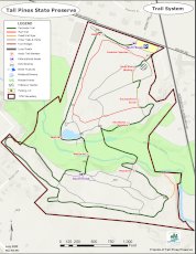
Trail System
There are just over 4 miles of serpentine trails within the park. The majority are asphalt, formerly used for golf carts. Sections of mowed grass are used to make logical walking paths in a few places. Two bridges are provided across Mantua Creek.
Presently two routes are officially marked:
- The Perimeter (Green) Trail is a 2.37 mile loop around the boundaries of the park, crossing both bridges.
- The Red Trail is a half-mile loop on the Deptford side of the park only.
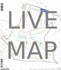
We have both interactive (GPS-enabled) and printable maps to guide you:
Animals and Plants
-

This map shows the plant habitats found in the park including plenty of example plants with pictures. Please see our blog post for more details on using the map.
-

Volunteers maintain a Bluebird Trail of 9 nesting boxes during the spring and summer. Learn more about bluebirds at Tall Pines.
- Here's an old but still useful list of birds, trees, and other wildlife that have been spotted at the property.
- The eBird website has up-to-date lists of Tall Pines bird sightings.
- John Dominy's photo gallery is a great photographic journey around the property.